DOWNLOAD MY NEW FREE JOESTRADAMUS WEATHER APP FOR ALL DEVICES
THE APP IS ABSOLUTELY FREE TO ALL BUT CONSIDERING SUBSCRIBING TO PATREON FOR A WEATHER EXPERIENCE FREE OF ADS, EXCLUSIVE VIDEOS FOR MEMBERS ONLY AND MUCH MORE…STARTS AT $2 A MONTH..MESSAGE ME AT ANY TIME
NYC SEVEN MEH DAYS AHEAD MOSTLY COOL
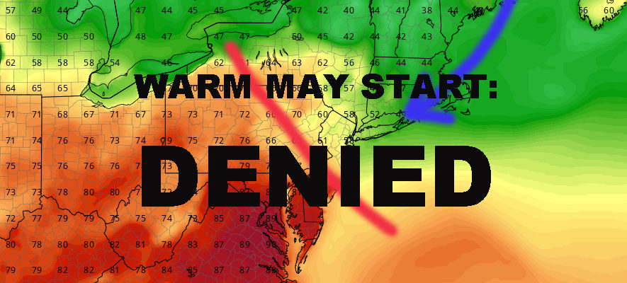
Good morning everyone. The outlook in the NYC area for the next week or so is not so great to put it plainly. We’ll have rain, but a lack of washouts; and sun with a lack of warmth. We’ll also get pretty close to very warm air, but get denied as the mid-Atlantic basks in the glory to start May. Such is Spring in NYC, where we get these little setbacks before things finally pop.
EASTERN SATELLITE

Low pressure exits the area today, leaving us a very sunny but also a windy day and breezy night. We’ll get into the upper 50’s to low 60’s today, but it won’t feel like it as we’ll have a few gusts to near 35mph. If we get to 60, that’ll put us about 5 or 6 degrees below average; not a disaster, but not great either.
Tomorrow, our next low pressure and reinforcing shot of cooler air swings on by. This will give us the chance of some afternoon showers, plus some snow in the highest elevations upstate. Nothing crazy, but tomorrow will be decidedly cooler than today; highs in the mid 50’s at best.
REGIONAL RADAR

To start the week, the sun returns with low 60’s, but clouds will increase late with our next approaching system. For Tuesday, clouds return and so does the chance of a few scattered showers. It also threatens to be the warmest day of the week as we get back to near average.
However, we find ourselves on the wrong side of the frontal boundary with this piece-meal system for mid-week. No washouts are expected throughout this whole thing, but we’ll have the chance of a few showers at any time and clouds will rule the roost. We’ll also be stuck in the cool, maritime fetch as the mid-Atlantic basks in 80’s; while we stumble and trip around in the low 60’s to round out the week.
LOCAL RADAR NEW YORK CITY

If everything times out right, we’ll clear things out for next weekend, but look for sunny, breezy and cool conditions; with possibly next Sunday being the “warmer” and less windy of the two days.
LOCAL RADAR PHILADELPHIA


In the long range, we are at the mercy of these fronts battling it out with the dense maritime influence. This is the way the time of season goes and is probably as old when Wooly Mammoths were roaming the Earth.
We are below average next week, but we’ve been average for the majority of spring so far. Eventually we will get a taste of the good stuff as things begin to settle down and all of that warmth building in the Midwest and Southeast will begin to inch further east and further north. At a minimum, I think we return to average after next weekend.
MANY THANKS TO TROPICAL TIDBITS FOR THE USE OF MAPS
Please note that with regards to any tropical storms or hurricanes, should a storm be threatening, please consult your local National Weather Service office or your local government officials about what action you should be taking to protect life and property.