
Weather in 5/Joe & Joe Weather Show Latest Podcast
NYC Severe Storm Watches Posted & Heat Returns Tuesday
Good afternoon everyone. Thunderstorms are starting to fire up off to our west, and we’ll be watching closely to see what pops up, where they go, and what survives the trip to NYC/Long Island.
SATELLITE

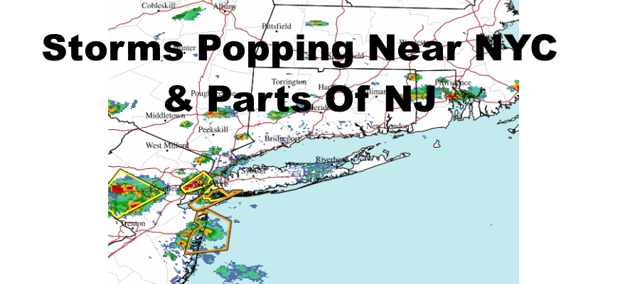
As of now, parts of Manhattan and Brooklyn are the only ones seeing some action as storms blow up, then slowly drift northeast. All we can do is wait and see how this unfolds, and some of these storms may weaken as they try to transit from the NJ coast to LI via the ocean. Anyone who does see the storms, could see torrential rain, flash flooding, frequent lighting, gusty winds, and some small hail.
WEATHER RADAR

Tomorrow we are cooler with some low to mid 80’s, and we might see a late shower or storm after some morning fog. Look for more of the same on Monday in terms of temps and the slight chance of a storm, but the winds swing around to a slightly drier flow, so no morning fog. However, we will have more clouds than sun.

The heat returns on Tuesday as upper 80’s to near 90 temps take hold again. As of now, I don’t see anything stopping upper 80’s to near 90 temps going until at least next Saturday or Sunday.
BE SURE TO DOWNLOAD THE FREE METEOROLOGIST JOE CIOFFI WEATHER APP &
ANGRY BEN’S FREE WEATHER APP “THE ANGRY WEATHERMAN!

MANY THANKS TO TROPICAL TIDBITS & F5 WEATHER FOR THE USE OF MAPS
Please note that with regards to any severe weather, tropical storms, or hurricanes, should a storm be threatening, please consult your local National Weather Service office or your local government officials about what action you should be taking to protect life and property.