
NYC SEVERE THUNDERSTORM THREAT DISCUSSION

NYC SEVERE THUNDERSTORM THREAT DISCUSSION
NYC SEVERE THUNDERSTORM THREAT DISCUSSION – Good early morning everyone! If you’re waking up now, you’re doing so to a beautiful and warm start to the day. However, clouds will be rolling in as the day progresses and the chance of showers and storms will increase in the early afternoon.
A cold front, helped along with an upper air disturbance behind it, will be the culprit today; and a squall line ahead of it will give us the chance of some severe thunderstorms. For the NYC area, Manhattan, Staten Island, Brooklyn, Bronx and parts of Queens, especially northern and western Queens, will have the best shot at seeing severe thunderstorms. For the Long Island area, although a severe weather warning can pop up at any time, western and northern Nassau has the better chance at seeing some severe weather action.
NYC SEVERE THUNDERSTORM THREAT DISCUSSION

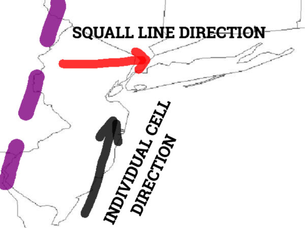
NYC SEVERE THUNDERSTORM THREAT DISCUSSION – Because of the angle of the approach, areas west of NYC will have the best chance overall to see severe weather. This includes large hail, damaging winds, frequent lightning, torrential rain, and isolated tornadoes. The squall line itself will be marching east, but individual cells will be head NNE; this typically lowers the chance of severe storms for most of Long Island due to cells having to travel over water before reaching land. For the NYC area, there is a better chance of severe storm cells surviving as they stay over land for most of the trip before briefly going over Raritan Bay in NJ.
Overall, the primary threat for the NYC area will be damaging winds, frequent lightning, and flash flooding. While this particular scenario might not be the prime setup for the NYC/Long Island area to see the most intense storms, the setup is ripe for flooding. With individual cells traveling NNE, we could see “training” take place, where strong cells continuously move over the same area. This could lead to some areas seeing copious amounts of rain and bad flooding, especially in the typical flood prone areas of the Belt Parkway, Jackie Robinson, Major Deegan, etc. We will be keeping a very close eye on this as things develop and progress.
After everything passes, we’ll have a beautiful block of weather tomorrow through Thursday, with low to mid 80’s tomorrow, mid 80’s to ring in Summer on Wednesday, and again mid 80’s on Thursday. On Friday, the humidity creeps up again as well as the chance of a few scattered storms, highs in the mid to upper 80’s. Heat and humidity continue for the weekend as we wait to see if an approaching front sucks up the tropical low that will be lurking in the gulf. For now, we’ll focus on today and then keep an eye on things for next weekend down the road.
Satellite View

NYC SEVERE THUNDERSTORM THREAT DISCUSSION – A cold front is tarting to make its approach into the tri-state area. The dim, milky white clouds in the Great Lakes area is some upper level energy that will help enhance the front as it passes by, giving us the chance at some severe weather.
Northeast Radar

Radar is already active with the remains of yesterday’s squall line, which should reform today and march east as individual cells move NNE. Severe storms are likely west of the NYC area, whereas we have a moderate chance at seeing some action. While Long Island may not see the most intense storms, very heavy rain is definitely on the menu.


NATIONAL WEATHER SERVICE SNOW FORECASTS
LATEST JOESTRADAMUS ON THE LONG RANGE
GET ANGRY BEN A NICE CIGAR!

Weather App

Don’t be without Meteorologist Joe Cioffi’s weather app. It is really a meteorologist app because you get my forecasts and my analysis and not some automated computer generated forecast based on the GFS model. This is why your app forecast changes every 6 hours. It is model driven with no human input at all. It gives you an icon, a temperature and no insight whatsoever.
It is a complete weather app to suit your forecast needs. All the weather information you need is right on your phone. Android or I-phone, use it to keep track of all the latest weather information and forecasts. This weather app is also free of advertising so you don’t have to worry about security issues with your device. An accurate forecast and no worries that your device is being compromised.
Use it in conjunction with my website and my facebook and twitter and you have complete weather coverage of all the latest weather and the long range outlook. The website has been redone and upgraded. Its easy to use and everything is archived so you can see how well Joe does or doesn’t do when it comes to forecasts and outlooks.
Just click on the google play button or the apple store button on the sidebar for my app which is on My Weather Concierge. Download the app for free. Subscribe to my forecasts on an ad free environment for just 99 cents a month.
Get my forecasts in the palm of your hand for less than the cost of a cup of Joe!
