
Weather in 5/Joe & Joe Weather Show Latest Podcast
NYC Short Range & Long Range Outlook
Good morning everyone and happy Saturday! We have a lot going on today through Friday and none of it is simple, but there are some things I see in the long range that I like, so we’re going to discuss that today as well. Let’s get to it.
SATELLITE
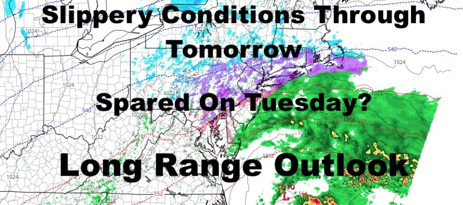
Clouds are lowering and thickening as we speak, and cold air is locked into the area. That’ll help set us up for a smorgasbord of precipitation, which is why Winter Weather Advisories have been posted by the NWS. Expect scattered light snow and sleet developing some time between afternoon and evening, then mixing with and possibly changing to all freezing rain. Highs today in the mid to upper 20’s, remaining steady overnight.
A dusting to an inch of snow is possible in areas that see some snow first, then a light accumulation of freezing rain. Precip overall will be light in nature, but that’s all you need to create big problems.
F5 WEATHER RADARS

We get this thing out of here a little earlier than previously expected, but not before some more light sleet and freezing rain tomorrow morning. Again, untreated surfaces may be very slick, so please take caution when walking or driving. Highs tomorrow will break freezing in spots, helping to melt whatever fell IF you treat the surfaces correctly. Highs in the low to mid 30’s.
Moisture ahead of Tuesday’s gathering system may give us another round of light snow, sleet, freezing rain, and rain on Monday, but we’ll have to revisit that tomorrow to see how things are developing. Highs Monday look to be in the low to mid 30’s as well.
A more organized and moisture-laden system will pass through on Tuesday, but it looks as if the NYC metro area may be spared the worst of it. As of now, the track fo our system looks like it may be far enough to the west to allow “warmer” air into the atmosphere to give us a period snow, sleet, and freezing rain changing to all cold rain. While not 100% ideal, it’s better than a prolonged period of wintry mix and ice throughout the duration of the system.

In the medium range, we have another system lurking for Thursday/Friday, and that one take a more westerly track; so much so, that 50’s and 60’s may creep up to southern or maybe even central NJ ahead of the cold front.
After that system, it looks like the very active pattern begins to break down. That doesn’t mean we will be precipitation free, but the endless system after system deal starts to wane. We also begin to see the gears of spring slowly turning across the Nation. Warmer air will begin to creep into the southwest and areas of the Gulf, and that’ll help add fuel the prospects of severe weather in TX and LA.
Systems out west will become more dynamic as they reach the Rockies and lower Midwest, giving a wide range of precip in a short span of miles – ranging from heavy snow to heavy thunderstorms.
While this doesn’t guarantee for us that spring weather is right around the corner in the Northeast, it shows a natural progression towards a more spring-like pattern. One thing is for sure, we are not done with cold weather up here, and way may not be done with snow yet, but there is light at the end of the tunnel.
BE SURE TO DOWNLOAD THE FREE METEOROLOGIST JOE CIOFFI WEATHER APP &
ANGRY BEN’S FREE WEATHER APP “THE ANGRY WEATHERMAN!

MANY THANKS TO TROPICAL TIDBITS & F5 WEATHER FOR THE USE OF MAPS
Please note that with regards to any severe weather, tropical storms, or hurricanes, should a storm be threatening, please consult your local National Weather Service office or your local government officials about what action you should be taking to protect life and property.