
Weather in 5/Joe & Joe Weather Show Latest Podcast
NYC Snow Performing Better Than Expected From Any Outlet
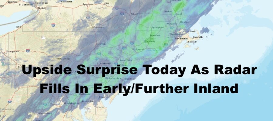
Good morning everyone. The radar has filled in earlier and more robust than anyone thought, so we take a step back and modify the snow totals. This is still a relatively light accumulation and not a major storm, but the high end of yesterday’s spectrum is now the low end.
SATELLITE

Look for light snow to continue today, and few spots may see some moderate snow at times. We’ll keep it going till some time between 4 and 7pm west to east. Total accumulations will be in the 2-4″ range instead of a coating to 2″ previously expected. Things got off to an early start and the radar is packed solid, so we have to adjust in regards. Highs will remain where we’re at now in the low 30’s. We dip into the upper teens to low 20’s overnight.
WEATHER RADAR

Tomorrow will be a very cold and blustery day, with highs in the mid to upper 20’s and stiff NW winds. Winds will begin to relax on Tuesday, and we go for mid 30’s.
We’ll warm up briefly, but won’t make it to the end of the week. Look for near 50 temps on Wednesday, then some rain and strong southerlies on Thursday with highs in the low to mid 60’s.
That front is on the move and it’ll be gone by early Friday, so sunshine is on the menu, but much cooler. We’ll dip back into the mid 40’s.

What we’re seeing today could be the last shot of snow for February as the pattern becomes very hostile to winter weather in the NYC Metro Area. With our midweek mild weather and system path, it kicks the can down the road to next week, which will give us another similar system with mild air. That’ll kick the can even further down the road, and we could get yet another Great Lakes runner and more mild air at the end of the month.
BE SURE TO DOWNLOAD THE FREE METEOROLOGIST JOE CIOFFI WEATHER APP &
ANGRY BEN’S FREE WEATHER APP “THE ANGRY WEATHERMAN!

MANY THANKS TO TROPICAL TIDBITS & F5 WEATHER FOR THE USE OF MAPS
Please note that with regards to any severe weather, tropical storms, or hurricanes, should a storm be threatening, please consult your local National Weather Service office or your local government officials about what action you should be taking to protect life and property.