NYC SNOW ROUND ONE

NYC SNOW ROUND ONE
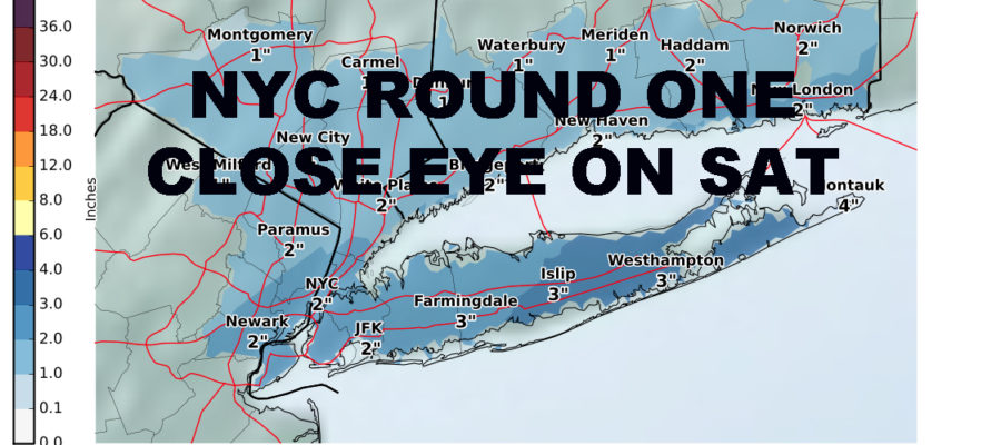
NYC SNOW ROUND ONE – Light snow is on our doorstep and should begin in the NYC area within the next 2 hours. The National Weather Service has caught up to my original forecast and the consensus is that 1-3″ is expected in most of the area aside from the east end of Long Island and Coastal NJ, which may see 2-4″ in some spots. Snow will be with us until around just after sunrise, then partial clearing tomorrow with highs in the mid 30’s. Tomorrow night will be unseasonably cold, with lows in the upper teens to near 20. Then we turn our eyes to Saturday, where we’re watching a close call unfold.
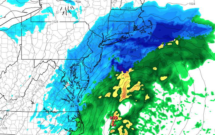
Above is the latest NAM model for Saturday afternoon. This is important as the NAM has been our most accurate source for the last few weeks in terms of short range forecasting. It doesn’t mean this scenario will happen, but it is a reason why to keep a close eye on what will unfold exactly. Right now, as things look, we are on the very fringe of the system, with a chance of flurries on Saturday afternoon. However, any wobble or change in the forecast by 50-100 miles, can make the difference between a dusting and several inches or more. Unfortunately, the way things have been going this season, we’ve been having to wait for the last minute to call the ball on many of these systems. This one will be no different and tomorrow evening will give us our best picture, so lets focus on tonight and tomorrow is another day.

NYC SNOW ROUND ONE – Satellite depicts very clearly our wave moving in, giving us some light snow accumulations overnight, with the next system waiting in the wings across the Mississippi valley.

Light snow is beginning to fill in across SE Pennsylvania and Central NJ. Snow will begin shortly and continue into early tomorrow morning.

FiOS1 News Weather Forecast For Long Island
FiOS1 News Weather Forecast For New Jersey
FiOS1 News Weather Forecast For Hudson Valley
NATIONAL WEATHER SERVICE SNOW FORECASTS
LATEST JOESTRADAMUS ON THE LONG RANGE

Weather App

Don’t be without Meteorologist Joe Cioffi’s weather app. It is really a meteorologist app because you get my forecasts and my analysis and not some automated computer generated forecast based on the GFS model. This is why your app forecast changes every 6 hours. It is model driven with no human input at all. It gives you an icon, a temperature and no insight whatsoever.
It is a complete weather app to suit your forecast needs. All the weather information you need is right on your phone. Android or I-phone, use it to keep track of all the latest weather information and forecasts. This weather app is also free of advertising so you don’t have to worry about security issues with your device. An accurate forecast and no worries that your device is being compromised.
Use it in conjunction with my website and my facebook and twitter and you have complete weather coverage of all the latest weather and the long range outlook. The website has been redone and upgraded. Its easy to use and everything is archived so you can see how well Joe does or doesn’t do when it comes to forecasts and outlooks.
Just click on the google play button or the apple store button on the sidebar for my app which is on My Weather Concierge. Download the app for free. Subscribe to my forecasts on an ad free environment for just 99 cents a month.
Get my forecasts in the palm of your hand for less than the cost of a cup of Joe!
