NYC Snow Wintry Mix Then Snow Again
Good afternoon everyone. We’re wading into a complicated forecast here, but nothing unexpected if you’ve been following the forecasts here. First and foremost, we’re looking to end the “snow drought” here in the New York City Metro Area. However, the forecast goes a little further than that and we are honing in on what to expect, how much, and a period of wintry mix.
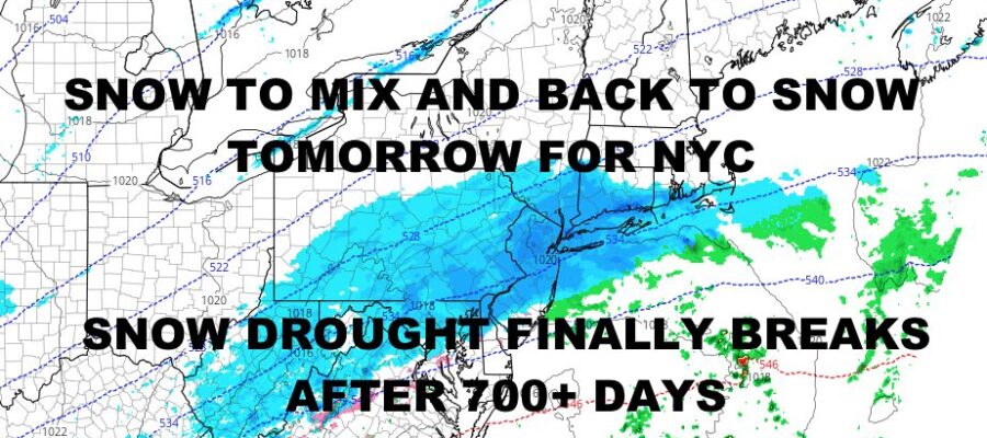
This is something we’ve been discussing the past few days as far as late development vs. early development of our low pressure system, as well as location of our low pressure. Right now, all signs indicate earlier development, which gives us a taste of some moderate precip mixed in with the light stuff; and we’re starting the action closer to the coast, which takes away the “heavier” amounts of snow away from the East End of Long Island, and shifts the heavier precip further west. It also gives us this period of mixing/ice in between the periods of snow expected before and after.
Overall this is a light to moderate event for most spots, with nothing outrageous expected in either direction. That being said, it’s noteworthy because it will end the snow drought and begin a brief pattern that could be more snow-friendly.
Here’s your local forecast –
SATELLITE

Clouds are already here, so we’re calling for a cloudy day instead of increasing clouds. Clouds will lower and thicken throughout the day, and that smell of snow will be in the air with a little bit of bite too. Look for highs in the upper 20’s to low 30’s. Overnight, light snow heads in and we could go moderate for a brief period. Lows in the mid to upper 20’s will assure that it is likely to stick everywhere except for salted roads. In NYC itself, the roads are slightly warmer due to everything running underneath them, so look for accumulations mostly on colder surfaces (Cars, grass, trees, steps, etc).
Tomorrow, light to moderate snow changes to a wintry mix with possibly some icing involved, Temps will hover near freezing to just a degree or two above. This wintry mix will happen after a pause in the snow, then we go back to snow as low pressure ramps up and departs. Overall, we are expecting 1-4″ of snow depending on how much mixing occurs. I understand that’s a wide range, but we have to see how the radar sets up before we can calculate how much mixing will keep accumulations down. Either way, it’ll be a hazardous situation due to slippery conditions, so use caution.
Anything that falls turns into a crunchy layer overnight as we dip into the 15-20 range.
WEATHER RADAR

Wednesday is sunny, blustery, and very cold with highs only in the mid to upper 20’s. Lows overnight don’t drop too much, but we are still in the low to mid 20 range fore a cold night.

We modify a bit on Thursday with increasing clouds and low 30’s, and we continue to watch our next system Friday for the chance of some more snow.
BE SURE TO DOWNLOAD THE FREE METEOROLOGIST JOE CIOFFI WEATHER APP &
ANGRY BEN’S FREE WEATHER APP “THE ANGRY WEATHERMAN!
MANY THANKS TO TROPICAL TIDBITS & F5 WEATHER FOR THE USE OF MAPS
Please note that with regards to any severe weather, tropical storms, or hurricanes, should a storm be threatening, please consult your local National Weather Service office or your local government officials about what action you should be taking to protect life and property.