OMNITRUEVALUE.COM

WEATHER IN 5/JOE & JOE WEATHER SHOW PODCASTS
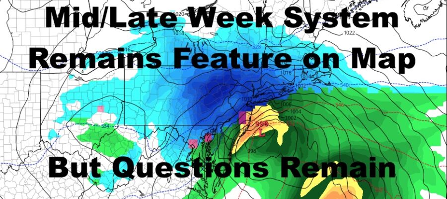
NYC Snowstorm Remains Feature On Map But Questions Remain
Good morning everyone. A complicated forecast remains, and we add to the complications due to low pressure coming closer to the area on Monday than previously forecasted. That system won’t impact us very hard, but it could affect the outcome of our Wednesday/Thursday system.
SATELLITE

For today, we are socked in with the clouds as moisture runs up the coast well ahead of our next system. That’ll give us some scattered rain this morning and into the afternoon, and highs will be a mild low 50’s.
REGIONAL RADAR

The rest of the system passes by tomorrow, but with little fanfare. Most of the energy goes well to our north and west, and that’ll give us a mix of sun and clouds tomorrow. It’ll be another mild one with highs 55-60.
LOCAL RADAR NEW YORK CITY

Monday is a little complicated as colder air heads in and low pressure gives us a brush instead of missing us. Looking at everything now, it may be cold enough for some mixed precip during the onset, then a change to cold rain. If the system is strong enough and gives us a little more than a brush, it could end as more mixed precip or a quick shot of wet snow. No accumulation is expected, but we could see colder surfaces whitened IF it goes to all snow. Highs Monday in the upper 30’s to low 40’s.
Tuesday is partly sunny and cold with highs near 40, then clouds increase late.
LOCAL RADAR PHILADELPHIA


I’m not ready to call the ball yet for Wednesday and Thursday. With Monday’s system edging closer to us, it may open up an avenue in which our bigger system comes closer to the coast or over us. That may equate to mess along the coast as far as varying types of precip during the evolution and position of the system.
There are still several paths this thing can take, and all options are on the table; which includes getting hammered with heavy snow, snow to mix to rain and back to snow, or a dud.
We’ll be keeping an eye on all of it, and I maintain that Monday morning’s model runs will be the most important in terms of showing us what direction this is going to go.
MANY THANKS TO TROPICAL TIDBITS FOR THE USE OF MAPS
Please note that with regards to any tropical storms or hurricanes, should a storm be threatening, please consult your local National Weather Service office or your local government officials about what action you should be taking to protect life and property.