NYC Summer Pop Up Storms Lurking Around Today As Heat Continues
Good morning everyone. We have a sunny start to the morning and we are well into the mid to upper 70’s already at 6:30am to start off your day. This time of year, that typically translates into 90+ degree weather, and we will see those numbers pan out once again. A slight cool off will happen tomorrow as light easterlies take over, but don’t go thinking it’s going to be a comfortable day.
SATELLITE

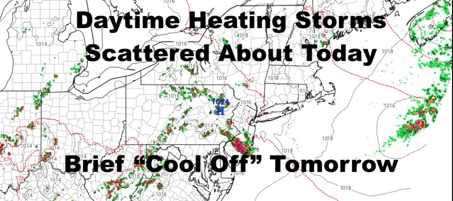
Sunshine will be with us all morning, then a slight wind shift to light southeast winds will increase the moisture throughout the area. Expect thunderstorms to begin popping up mid to late afternoon in the Northeast. Typically with this setup on a hot day, we’ll see most of the action just inland from the coast, but we could see some stray action in the NYC/Long Island area as well. Anything that does pop up will be strong in nature, and possibly locally severe. Highs today will be in the near 90 to low 90 range.
REGIONAL RADAR

Tomorrow we “cool” down into the mid 80’s with the easterly influence, but again, mid 80’s and east winds are nothing to write home about. It’ll be a humid day and we’ll also have the slight chance of a storm.
As winds shift back around, we are back to near 90 conditions on Wednesday with the slight chance of a storm.
LOCAL RADAR NEW YORK CITY

Thursday will be our “driest” day with the thunderstorm action suppressed, but we are most likely going for low to mid 90’s for a hot one.
For Friday, as of now I’m still going with another 90 degree day, but also keeping an eye on a wave of low pressure that might ride up an approaching cold front. We could be entering an unsettled period as the mechanics get iffy in the atmosphere as far as moving things along.
If that front hangs up on the east coast, we might see an increased chance of storms Friday through Sunday, and temperatures held back a bit. (Although it’ll still be very warm & very humid)
LOCAL RADAR PHILADELPHIA


Beyond that, we continue to watch heat that wants to build a greater lock on the Midwest and points eastward for mid-month. However, if things get iffy front-wise for the east coast as far as moving things along, we may not achieve “heatwave” status as far as a textbook standpoint. There is still the potential for 95-100 degree weather for late week/weekend of the 17th, but it looks to be a broken chain of hot days and very warm days next week leading up to that.
Stay tuned because if the fronts don’t get hung up along the coast, we will be sizzling.
MANY THANKS TO TROPICAL TIDBITS FOR THE USE OF MAPS
Please note that with regards to any tropical storms or hurricanes, should a storm be threatening, please consult your local National Weather Service office or your local government officials about what action you should be taking to protect life and property.