NYC SUNDAY MONDAY FLURRY SPRINKLE POSSIBILITY REMAIN
Good morning everyone. Leftover clouds and sprinkles are hanging on early this morning in the New York City area, but clearing should ensue as the morning goes on. A weak system overnight tomorrow and Monday, bringing a reinforcing shot of cold air, remains on the radar but shouldn’t amount to much for the NYC metro area.
EASTERN SATELLITE

Lingering clouds and drizzle are stubborn to leave this morning as our big system from yesterday is slow to move out. The clouds I expected, but the drizzle is little bit more feisty than I thought it would be. So just bear with it for a few hours and I promise some sun, and some wind, is coming.
Expect clearing skies today with a blustery west wind and highs steady in the low 40 range.
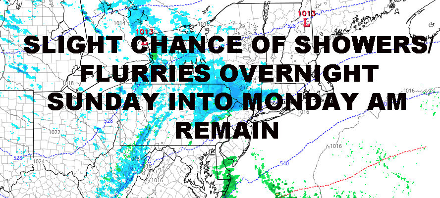
REGIONAL RADAR

For tomorrow, the wind calms down significantly, but it’ll still be steady enough to create a cold wind chill. We’ll have clouds and sun, more clouds than sun as sunset arrives, and highs in the low 40’s.
Clouds continue to lower and thicken overnight tomorrow as a weak piece of energy moves across the Great Lakes and Ohio Valley; representing a reinforcing shot of seasonably cool/cold air behind it. This will touch off an area of scattered light snow upstate and some of that moisture could give us a chance of flurries and sprinkles down here.
If things set up right, there could be a thin band of 1-3″ of snow Sunday night into Monday; just in time for a picturesque Christmas Eve day well north and west of the NYC area, so we’ll be keeping an eye on it to see if it develops and who will see it.
Otherwise for us, any flurries will turn to cold sprinkles/light rain early Monday before we clear out as the day goes on; highs in the upper 30’s to low 40’s.
LOCAL RADAR NEW YORK CITY

Christmas Day remains looking beautiful for those who don’t mind the lack of snow. Sunny, seasonably cool, and comfortable is the best way to describe it. Highs 35-40 in most areas with no chance of any precip.
LOCAL RADAR PHILADELPHIA


The end of next week, onward, remains looking active in terms of systems racing across the Country. Our next system late next week continues to look like another soaker, and the system after that will be lurking around New Years Eve. The jury is still out on that one in terms of path, strength, speed, and size, so we’ll be watching closely to see if we actually get any precip at all for New Years.
FiOS1 News Weather Forecast For Long Island
FiOS1 News Weather Forecast For New Jersey
FiOS1 News Weather Forecast For Hudson Valley
NATIONAL WEATHER SERVICE SNOW FORECASTS
LATEST JOESTRADAMUS ON THE LONG RANGE