NYC Tropical Update Plus Long Range Forecast
Good morning everyone. We have a lot to go over in terms of the tropics, plus we have a look at our long range forecast that is looking rather interesting heat-wise. First, we go to the tropics where Hurricane Franklin continues to churn up those seas and sends some big swells our way. That’ll equate to rough surf and inlets in the area for a few more days until its departure well out to sea.
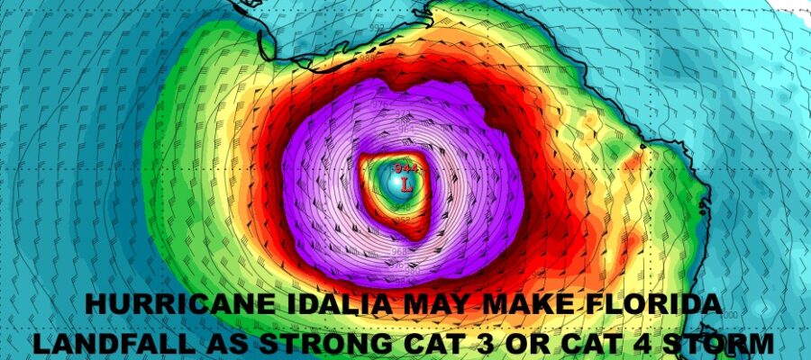
The main focus is not our story here in NYC, but down south where we continue to watch Hurricane Idalia. As we speak, it has winds of 80mph sustained and pressure is dropping rapidly. That is the sign of a system that’ll jump in intensity fairly quickly. We are estimating that this point that Idalia may may landfall as a strong Category 3 or “minimal” Category 4 hurricane somewhere in between Apalachicola & Horseshoe Beach Florida, then head across the peninsula, into Georgia, then ride the GA/SC coast just inland, before exiting out somewhere of the NE South Carolina coast.
The worst damage will be confined to the FL coast, but it will pack enough punch to keep it tropical storm strength through its ride inland. Flooding rains, intense squalls, severe weather, brief tornadoes, and tropical storm force winds are expect in parts of Georgia, South Carolina, and North Carolina. Hurricane force gusts will be possible in the heaviest rain bands.
We’ll be watching this closely as it unfolds. Check out your local forecast and long range below…
SATELLITE

Clouds stick around today and tomorrow with the chance of a few showers and rumbles. It won’t be a full washout, but keep the umbrella handy. Highs today will be in the upper 70’s, then low 80’s tomorrow and humid.
WEATHER RADAR

Thursday and Friday are looking perfect, with sunshine and highs in the upper 70’s to near 80. We’ll line another perfect day up for Saturday with sunshine and near 80 temps, then we go much warmer for Sunday. The dead air left behind all of these systems will begin to unlock some of the heat in the midwest and allow it to drift eastward. Look for sunshine, increasing humidity, and highs in the mid to upper 80’s.

For your long range, we talked about the prospects of some heat in September since August wasn’t very hot; and it looks as if this is coming to fruition. Our departing tropical activity and high pressure protecting us, will allow that ridge to build over the area to give us a fairly big stretch of very warm to hot conditions.
For the start of the workweek on Monday, look for sunshine and highs in the upper 80’s. Tuesday we go for upper 80’s to near 90, then Wednesday we could flirt with or break 90. This trend looks like it continues into the September 8th-10th range, then we begin to come back to reality temp-wise.
BE SURE TO DOWNLOAD THE FREE METEOROLOGIST JOE CIOFFI WEATHER APP &
ANGRY BEN’S FREE WEATHER APP “THE ANGRY WEATHERMAN!
MANY THANKS TO TROPICAL TIDBITS & F5 WEATHER FOR THE USE OF MAPS
Please note that with regards to any severe weather, tropical storms, or hurricanes, should a storm be threatening, please consult your local National Weather Service office or your local government officials about what action you should be taking to protect life and property.