NYC Weekend System Still Reality With Chilly Air Behind
Good morning everyone. Clouds continue to stick around this morning, but we should finally get into some blue breaks as the day goes on. Even with those breaks in the clouds, we could see a shower or two pop as that sun works the atmosphere and some upper level energy hangs around.
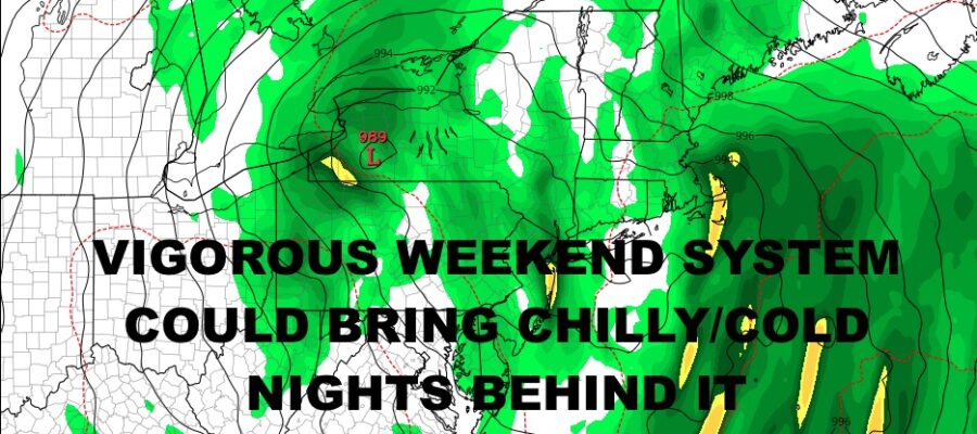
Aside from that, our workweek continues to look very quiet until Friday. That’s when clouds will increase ahead of our next system, and we could see a few showers before a rainier Saturday. That system should be strong enough to wrap some relatively chilly to cold air behind it, giving us some crisp nights and the chance of some frost and freeze warnings/watches popping up in areas of the Northeast.
While I don’t believe we’re done with the mild air yet, even with a few crisp nights and very cool days ahead, I do believe this system sets the stage in the long run for another push of even chillier air around the time of Halloween or just beyond it.
SATELLITE

Morning clouds will give way to a few blue breaks today. That sun (if any), should be enough to touch off a few widely scattered popcorn showers. Highs today will be near 60.
Look for sun and clouds tomorrow, with more highs near 60.
WEATHER RADAR

Wednesday and Thursday are winners, with full sunshine and comfortable temps. Highs should be in the mid 60’s for Wednesday, then 65-70 on Thursday.
Clouds increase Friday with the chance of showers developing ahead of our next system. It’ll be a damp and humid one, with highs in the mid to upper 60’s.

Look for a showery day on Saturday with gusty winds developing. Highs will be 60-65. As of now, I’m thinking we don’t get the coastal component for Sunday, but low pressure will be strong regardless. As it passes into New England, we should see some partial clearing and a windy day starting off in the 55-60 range, then dropping before sunset.
As far as cold or chilly air is concerned, I think there will be a 24 hour delay in terms of when the core of the air hits. Our chilliest/coldest nights in this stretch, should be next Tuesday and Wednesday night. Lows could be in the upper 30’s to low 40’s in then NYC area, 35-40 on Long Island, and we could see some 20’s and low 30’s well N&W of NYC.
BE SURE TO DOWNLOAD THE FREE METEOROLOGIST JOE CIOFFI WEATHER APP &
ANGRY BEN’S FREE WEATHER APP “THE ANGRY WEATHERMAN!
MANY THANKS TO TROPICAL TIDBITS & F5 WEATHER FOR THE USE OF MAPS
Please note that with regards to any severe weather, tropical storms, or hurricanes, should a storm be threatening, please consult your local National Weather Service office or your local government officials about what action you should be taking to protect life and property.