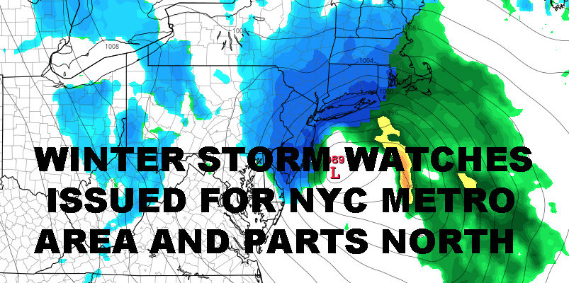
SNOWY NYC NOREASTER EXPECTED WINTER STORM WATCH ISSUED
SNOWY NYC NOREASTER EXPECTED WINTER STORM WATCH ISSUED
SNOWY NYC NOREASTER EXPECTED WINTER STORM WATCH ISSUED – Good morning everyone. I stated a few weeks ago, the worst of the cold may be over, but that doesn’t mean we can’t get a surprise as far as snow. Well, it looks like parts of the area are in for it, now we just have to hone in on where.
Winter Storm Watches have been posted from Wednesday night starting at midnight, until early Thursday morning around 6am. Last week’s Nor’Easter, slow departure, and subsequent seasonal temps will help set the stage. Today will be partly to mostly sunny, a stuff northerly breeze continuing, and highs in low to mid 40’s; normal this time of year. Tomorrow, we get some brief sun, then increasing clouds throughout the day and highs in the mid 40’s. The wind finally calms down, but it’s the proverbial calm before the storm.
With cool air locked in and an approaching system, this will help make the air just cold enough for snow once our secondary low gets going. As stated yesterday, look for low pressure to ride up through the Ohio Valley and into the Great Lakes region, then transfer its energy to the coast. This scenario will be slightly different than Friday’s for several reasons.
First and foremost, the transfer will happen faster and actually at the coast, whereas last weeks transfer initially happened over land before blowing up off of the coast. This will allow colder air to come in and our snow to begin earlier in the timeline of this Nor’Easter. Also, it’ll be moving faster, which will spare us some complications, but it’ll be more compact; making the forecast more difficult in terms of who sees what.
So as of now, it looks like we start off late Tuesday night with a rain changing to mix. Rain and snow continue Wednesday morning, then at some point during the day we change to all snow. When this change occurs, how early, and how heavy, will dictate what our final outcome will be as far as accumulations. Snow continues Wednesday night, but should end before midnight and thereafter west to east.
First Initial Snow Map – Confidence Moderate

The melt begins of Thursday with clouds and sun, highs in the mid 40’s, but it looks like we might have 6-12+” of snow to melt when all is said and done. Because this storm is so compact and models continue to differ slightly on path, I’m going to say the bust potential is moderate in specific areas and categories.
First will be who sees the heaviest of the snow, we won’t know that until we see the actual structure of the system. Then, we have Long Island. Will Suffolk see the highest amounts? Or will mixing or a longer period of rain keep accumualtions down. The joys of forecasting this area, especially in early March, are shining though. Also, depending on final path and strength, we could see a small area of Blizzard Warnings pop up, but that area is yet to be determined and will most likely be Long Island if it can hold onto an all-snow situation.


NATIONAL WEATHER SERVICE SNOW FORECASTS
LATEST JOESTRADAMUS ON THE LONG RANGE
Weather App

Don’t be without Meteorologist Joe Cioffi’s weather app. It is really a meteorologist app because you get my forecasts and my analysis and not some automated computer generated forecast based on the GFS model. This is why your app forecast changes every 6 hours. It is model driven with no human input at all. It gives you an icon, a temperature and no insight whatsoever.
It is a complete weather app to suit your forecast needs. All the weather information you need is right on your phone. Android or I-phone, use it to keep track of all the latest weather information and forecasts. This weather app is also free of advertising so you don’t have to worry about security issues with your device. An accurate forecast and no worries that your device is being compromised.
Use it in conjunction with my website and my facebook and twitter and you have complete weather coverage of all the latest weather and the long range outlook. The website has been redone and upgraded. Its easy to use and everything is archived so you can see how well Joe does or doesn’t do when it comes to forecasts and outlooks.
Just click on the google play button or the apple store button on the sidebar for my app which is on My Weather Concierge. Download the app for free. Subscribe to my forecasts on an ad free environment for just 99 cents a month.
Get my forecasts in the palm of your hand for less than the cost of a cup of Joe!