STUBBORN LOW PRESSURE COULD MAKE SLOW NYC EXIT
STUBBORN LOW PRESSURE COULD MAKE SLOW NYC EXIT
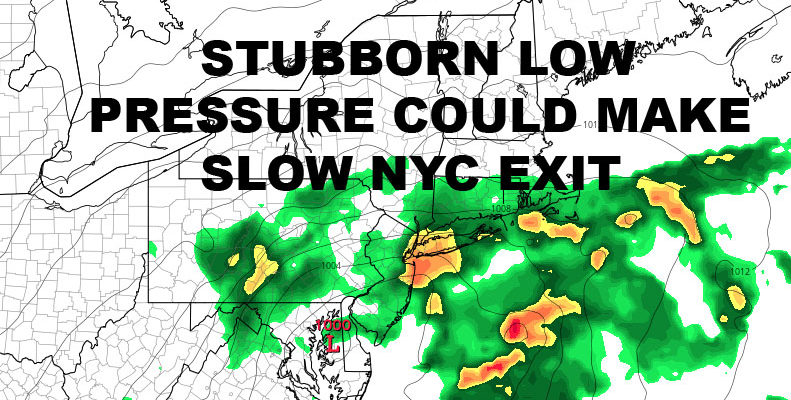
STUBBORN LOW PRESSURE COULD MAKE SLOW NYC EXIT – Waking up this morning, I am reminded of the crazy winter and spring season 2017 was. We jump right back into the craziness and examine what on earth is going on. First off, we’ll have a cloudy and somewhat humid day as a wave of energy ahead of a weak frontal boundary goes to our north. This will take most of the rain with it, but with the heating of the day and the tail end of the energy sinking south as the day wears on, we could see the slight chance of a shower or storm. As stated yesterday, anyone who sees one of these storms may experience some small hail and gusty winds. Highs today should top out near 80.
Low pressure will be stubborn to get its act together, but eventually transfer to the coast somewhere south of Long Island. Because things are moving a little slower, we should squeeze out a decent day tomorrow. We’ll have clouds and sun, slight chance of a thunderstorm as the energy starts to meld, and highs in the mid 80’s. We still have to wait and see how long everything takes to come together and where, so for now I’m calling for rain starting after midnight, becoming more steady by sunrise on Saturday. For Saturday, we’ll have brisk NE winds and rain, possibly heavy at times depending on where the main focus of energy sets up. Highs on Saturday may only reach 70.
Then we wait to see if this low pressure gets hung up and/or leaves the upper level low over central PA lingering for a few days. Right now I’d say it’s 50/50 in terms of this system clearing out fully by Saturday night vs. it lingering for an extra day or two. At this moment, the Euro and GFS have it lingering and the NAM has it fully moving out by early Sunday morning, so I’m going with something in between. For now, I’ll say we’re looking cloudy for Sunday, maybe some partial clearing late, but NE winds will be stubborn and keep things at a cool-feeling 80 degrees. Monday, things will try to clear out more and the air will modify, but NNE winds will linger, keeping temperatures at a near normal low to mid 80’s.
I’m thinking by Tuesday we should start pumping the humidity back in, and by Wednesday the heat is back for that period of above average heat and humidity I’ve been talking about for quite some time. We’ll have to wait and see what this system does to the jet stream and our overall pattern, but as of now, I think we still see big heat return, and we might not see the break in heat we should’ve seen next weekend. You can thank this system for that if this is the case.
Anomalies test my patience, but we will get through it. As always, I’ll do my best to give you the most accurate forecast possible.
Satellite View
STUBBORN LOW PRESSURE COULD MAKE SLOW NYC EXIT – The bulk of today’s energy goes to our north, clearing the way for a decent Friday. Then we watch overnight tomorrow for the gathering of a low pressure system, steady rain, and gusty chilly NE winds.
Northeast Radar
The bulk of the rain goes to our north today, but the heating of the day and the tail end of energy sinking south, could give us the chance of a few scattered storms in the area. Then we’ll have a pretty quiet day tomorrow aside from the chance of a renegade shower or storm.
NATIONAL WEATHER SERVICE SNOW FORECASTS
LATEST JOESTRADAMUS ON THE LONG RANGE
GET ANGRY BEN A NICE CIGAR!
Weather App
Don’t be without Meteorologist Joe Cioffi’s weather app. It is really a meteorologist app because you get my forecasts and my analysis and not some automated computer generated forecast based on the GFS model. This is why your app forecast changes every 6 hours. It is model driven with no human input at all. It gives you an icon, a temperature and no insight whatsoever.
It is a complete weather app to suit your forecast needs. All the weather information you need is right on your phone. Android or I-phone, use it to keep track of all the latest weather information and forecasts. This weather app is also free of advertising so you don’t have to worry about security issues with your device. An accurate forecast and no worries that your device is being compromised.
Use it in conjunction with my website and my facebook and twitter and you have complete weather coverage of all the latest weather and the long range outlook. The website has been redone and upgraded. Its easy to use and everything is archived so you can see how well Joe does or doesn’t do when it comes to forecasts and outlooks.
Just click on the google play button or the apple store button on the sidebar for my app which is on My Weather Concierge. Download the app for free. Subscribe to my forecasts on an ad free environment for just 99 cents a month.
Get my forecasts in the palm of your hand for less than the cost of a cup of Joe!


