Very Warm Monday Expected in New York City
04/27/24 11:40am ET
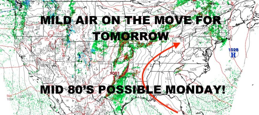
Good morning everyone. Mild air is on the move today towards the Northeast, and this should be the last of the very cool days for at least the next 7 days or so. 60’s will be replaced by 70’s tomorrow, then 70’s will be replaced by mid 80’s for Monday. After that, we sink back down towards reality and fairly seasonable temps, but the extreme cool temps stay away for a little while.
The big story remains the Midwest, where we will see more problems reveal itself this afternoon after a rough night last night. We continue to watch waves of low pressure exit the Rockies, tapping the Gulf moisture, and firing up severe weather with the help of daytime heating and some shear in the mid & upper layers of the atmosphere.
We’ll be watching closely for a significant outbreak of severe weather, including the chance of numerous strong tornadoes possible in areas such as Kansas, Oklahoma, Texas, Missouri, and Iowa. The action will come in two waves, with the first developing this afternoon in several clusters/lines and racing east/northeast. Then later this evening and into tonight, we’ll see more development that’ll be more widespread and even more severe in nature.
Expect widespread damaging winds, large hail, torrential rain, and strong tornadoes. The time frame on this action looks to be from early to late afternoon today, into late morning tomorrow from west to east & northeast. Please stayed tuned to your local agencies for advisories and warnings that may require you to take action in order to save life and property.
Here is your local NYC Metro forecast –
SATELLITE

Look for a mix of sun & clouds today. Cool air remains as we hang out in the upper 50’s to low 60’s. Tomorrow is a different story as mild air finally reaches us. Expect mid 70’s under a mix of sun & clouds. We can’t rule out a scattered shower or sprinkle during this process.
WEATHER RADAR

Monday continues to look warmer than previously expected as light northerly winds will help give us that early season “boost” of sinking dry air. Sinking air heats up fast and efficiently, so we could have mid 80’s on our hands in many spots. Depending on the wind profile, don’t be surprised if you see some upper 80’s in spots.

It all comes to an end on Tuesday as a frontal boundary will bring cooler air. We don’t expect anything extreme through temp-wise as we sink back into the upper 60’s. Look for the chance of PM showers and storms as well.
Wednesday through Friday, we dry out and bounce back into the near 70/low 70 category with a mix of sun & clouds.
BE SURE TO DOWNLOAD THE FREE METEOROLOGIST JOE CIOFFI WEATHER APP &
ANGRY BEN’S FREE WEATHER APP “THE ANGRY WEATHERMAN!
MANY THANKS TO TROPICAL TIDBITS & F5 WEATHER FOR THE USE OF MAPS
Please note that with regards to any severe weather, tropical storms, or hurricanes, should a storm be threatening, please consult your local National Weather Service office or your local government officials about what action you should be taking to protect life and property.