Weekend Winter Storm Possibility Holds On Tight
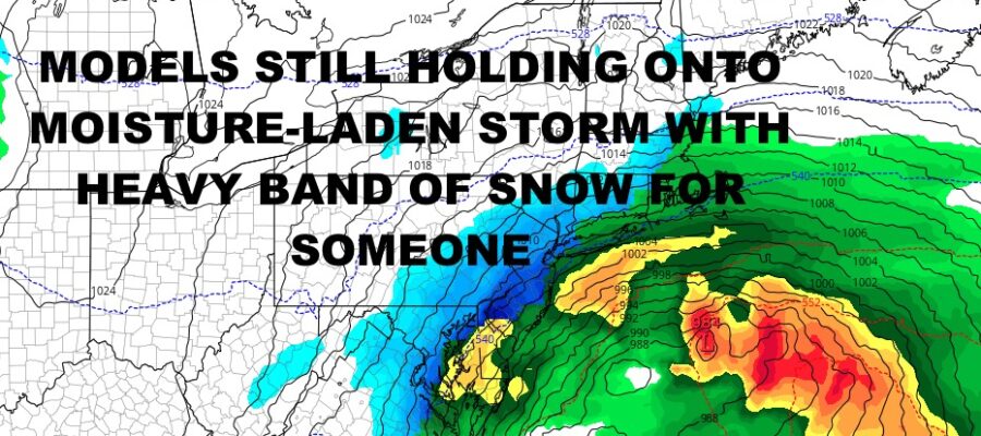
Good morning everyone. While some are nursing a hangover, we’re back to work right away today and trying to decipher what to expect this weekend as far as a possible winter storm. There are a few things we can tell you that we do know, and a few things that we don’t. The biggest thing is that weather models (now essentially all of them), are holding onto the idea of a big winter storm for the Mid-Atlantic, Northeast, and parts of New England.
Our “near-miss” for Thursday is right on schedule, helping to bring clouds and cold air behind it. We’re not expecting much if anything at all from this; a flurry or sprinkle at best. What we are expecting is that high pressure will build into the Northeast, giving us a cold day on Friday with only slightly moderating temps on Saturday. That’ll set the stage for Saturday night/Sunday in terms of not taking much for it to be cold enough for snow and/or mixed precipitation.
Our disturbance will move across the Lower Mid-West and Gulf, tapping that juicy Gulf moisture as high pressure moves off the East Coast. Another high pressure system will build down from Canada helping to reinforce the cold air. This is where timing, positioning, and strength of that high pressure system becomes extremely important. If it builds in too early or in the wrong spot, our low will be able to nudge close to the coast and send more rain than snow to coastal side of the I95 corridor, with heavy snow inland and west/northwest of I95. If it builds in too far south, too late, and too strong, it’ll suppress everything further south, giving the Mid-Atlantic and southern NJ a hefty snowstorm.
Then you have the “Goldilocks” scenario, where everything works out “just right” and major cities from Washington DC, to Philly, to NYC, get walloped. Regardless of how this plays out, I think this system will be capable of a general 6-12″+ snowfall of the heavy wet snow variety, plus higher amounts in the 1-2ft range in higher elevations and/or if banding sets up.
We will continue to watch this, but realistically Thursday’s system is detrimental and we won’t get a clearer picture until that system departs. Forecasting a system behind a system is very challenging and very unpredictable. This is why we take the methodical approach – pointing out the possible “problem”, seeing if the problem still exists, then trying to figure out how it’ll play out if it remains a viable feature.
Thank you all for tuning in, Happy New Year, and here is your local forecast into Saturday –
SATELLITE

Extra clouds continue to be stubborn today, so look for clouds and sun, maybe some extra blue breaks this afternoon, and highs in the low to mid 40’s.
Sunshine wants to return tomorrow, and we hold onto those low to mid 40’s.
WEATHER RADAR

Expect more of the same on Wednesday, then increasing clouds Thursday with highs a cooler near 40/low 40 range. Friday is a cold and breezy one, with highs in the mid to upper 30’s.
For Saturday, look for AM sun, then increasing clouds late. Highs will be in the near 40/low 40 range, then low 30’s overnight as we watch the approach of that system.

BE SURE TO DOWNLOAD THE FREE METEOROLOGIST JOE CIOFFI WEATHER APP &
ANGRY BEN’S FREE WEATHER APP “THE ANGRY WEATHERMAN!
MANY THANKS TO TROPICAL TIDBITS & F5 WEATHER FOR THE USE OF MAPS
Please note that with regards to any severe weather, tropical storms, or hurricanes, should a storm be threatening, please consult your local National Weather Service office or your local government officials about what action you should be taking to protect life and property.