WINTER STORM WARNINGS REGENERATED HEAVY NYC SNOW EXPECTED
WINTER STORM WARNINGS REGENERATED HEAVY NYC SNOW EXPECTED
WINTER STORM WARNINGS REGENERATED HEAVY NYC SNOW EXPECTED – Good morning everyone! First and foremost, for those waking up this morning to nothing or just a coating in areas, asking themselves, “What happened?”, this was always a Wednesday-focused system and it’s coming. The first batch of precip overnight was front-related, now we have to wait for our compact low pressure system to fully arrive.
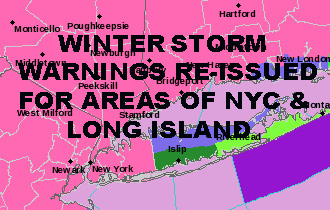
Winter Storm Warnings have been re-issued for southern parts of Nassau County, as well as Queens in New York City. That’s why we had to wait for the system to form to see exactly how this thing looks structure-wise and how much cold air is was able to pull in. Proximity of low pressure to New York City and Long Island will still be an issue, and the heaviest of snow will still be focused N&W of the NYC area. However, NYC and Nassau County will get in on the action even though mixing will occur at times.
Although not as intense as Friday, Coastal flooding and wind will still be an issue. Look for tide departures above normal at high tide, and winds gusting to 45mph in areas, especially at the coast and even stronger on the Forks of Long Island. This can be problematic for structures and trees weakened by the strong winds of Friday’s Nor’easter.
The Snow Map Stays
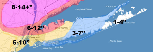
Call me stubborn, call it what you want, but the snow map stays with no modifications. I think we’re on the right path, or fairly close enough not to touch anything after seeing what the Nor’easter looks like this morning. For areas, north and west of NYC, it’ll be all snow, so expect the largest amounts.
For us here in NYC and Long Island, we should have a healthy dose of snow come late morning into the afternoon, then mixing with sleet and/or rain as the low gets closer and more intense. At the end, we should go back to all snow as colder air is re-introdicued and we tack on another coating to 3″ (in the warning areas). For Suffolk, the further east you go, the more mixing you’ll see and amounts will be kept down. It’s possible that the east end may reach their mark at the end, not in the beginning.
So I think we reach these numbers in a round-about, piece-meal way, possibly coming in two parts as we experience both the colder and possibly warmer quadrants of this system in areas. Either way, everything comes to an end by midnight (west to east) and we’re just left with some widely scattered showers tomorrow, a windy day, and low 40’s as highs.
Stay tuned for updates as everything unfolds.


NATIONAL WEATHER SERVICE SNOW FORECASTS
LATEST JOESTRADAMUS ON THE LONG RANGE
Weather App

Don’t be without Meteorologist Joe Cioffi’s weather app. It is really a meteorologist app because you get my forecasts and my analysis and not some automated computer generated forecast based on the GFS model. This is why your app forecast changes every 6 hours. It is model driven with no human input at all. It gives you an icon, a temperature and no insight whatsoever.
It is a complete weather app to suit your forecast needs. All the weather information you need is right on your phone. Android or I-phone, use it to keep track of all the latest weather information and forecasts. This weather app is also free of advertising so you don’t have to worry about security issues with your device. An accurate forecast and no worries that your device is being compromised.
Use it in conjunction with my website and my facebook and twitter and you have complete weather coverage of all the latest weather and the long range outlook. The website has been redone and upgraded. Its easy to use and everything is archived so you can see how well Joe does or doesn’t do when it comes to forecasts and outlooks.
Just click on the google play button or the apple store button on the sidebar for my app which is on My Weather Concierge. Download the app for free. Subscribe to my forecasts on an ad free environment for just 99 cents a month.
Get my forecasts in the palm of your hand for less than the cost of a cup of Joe!